- ホーム
- English Website
- What weve done & What we do
- Ubiquitous Flood Hazard Maps start in Takeo,spring 2011
Ubiquitous Flood Hazard Maps start in Takeo,spring 2011
MLIT Takeo River Office collaborated with three local communities and developed the first “ubiquitous flood hazard maps” in Rokkakugawa and Matsuuragawa basins in Spring 2011.
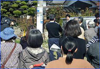
Takahashi District, Takeo City (Rokkakugawa basin) on 13 March 2011
Okawa District, Imari City (Matsuuragawa basin) on 22 March 2011
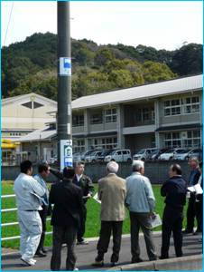
Tachibana District, Takeo City (Rokkakugawa basin) on 6 April 2011
What is “Ubiquitous Flood Hazard Map”?
There have been started an effort on standardizing marks for flood signs in Japan, called “Ubiquitous Flood Hazard Maps (Comprehensive Town-Wide Hazard Maps)”. Japan enhances the signs of flooding in downtowns for the purpose of people’s understanding about flooding, such as traces of flooding and the evacuation area during flooding. The signs follow the special advisory committee for “signs of flooding” and “designs for flooding signs”. The committee recommended the guidelines for hazard mapping through signs of flooding in “Manual for Making Flood Hazard Map Ubiquitous”. (Japanese only, but Box below shows its summary)
http://www.river.or.jp/pict_flood/zukigou_download.htm
The aim of this manual is to help bring about safe and smooth evacuation necessitated by floods and to help minimize flood damage by providing facts and encouraging the dissemination of knowledge of possible flood water depths and shelters and raising awareness of risks by displaying information on flood water depths and shelters in the form of flood-related signs in towns. Along with the recent amendment to the Flood Fighting Law, progress has been made in designations and announcements of flood-prone areas and in preparing flood hazard maps. To help meet the need for wide dissemination of flood information, the guidelines show how flood signs enable residents to appreciate the real risk of floods in their areas and provide more information on flood response required in communities.
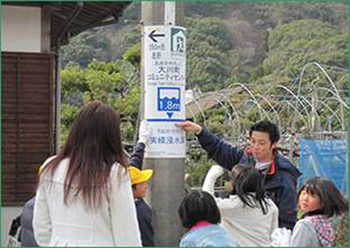
Box Standardized marks for flooding in JapanThe manual establishes three categories of information to be provided by flood-related signs: Flood (flood water depths), Shelters, and Levees. The symbols indicated below are specified for nationwide use in providing each kind of information under the principles of:
Flood[Meaning of the symbol]
[Purpose of the symbol]
Shelter building[Meaning of the symbol]
[Purpose of the symbol]
|


Why Flood signs?
Flood signs are effective means of communication of flood maps. Flood risks can be reduced not only by decreasing the magnitude of hazards, but also by reducing exposure of people and their activities to flooding and diminishing the vulnerability of flood-prone communities. Through sustaining people’s awareness for flood risks, flood signs can put an impact on whether the people who are exposed to the hazard are vulnerable to the hazard or not. Sustaining people’s awareness is a critical point for making mapping effective on flood management and enhancing communication with stakeholders including local inhabitants. It is not easy because the awareness diminished as time passes even though people are aware of flood risks just after major floods. Most community residents lack information on major regional flood damage in the past and lack knowledge of projected flood water depths in the area in which they live and other facts pertaining to flood risk. Dissemination and communication with the stakeholders regarding flood mapping are essential for sustainability of people’s awareness. Risk awareness means to recognize the hazard, to understand the mechanism and the impact, not to forget to repress it, and to take into account when acting. The aims of flood signs are to promote the further dissemination of flood hazard maps, to create a heightened sense of risks and better awareness of shelters in case of floods in each community, and facilitate community participation in flood risk assessment as well as in planning and implementation of risk management measures.
How integrate the signs into community activities?
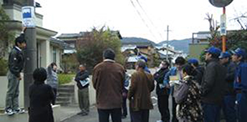
The standardized marks, which MLIT Takeo River Office has just applied, include signs which mean flooding, evacuation (areas) and levees so that travelers or foreigners who are not familiar to local backgrounds can also understand them easily. It should be noted that describing the hazards without giving advice what to do is useless. This makes people fear and just enhance repressing of the hazard. Flood signs are to be combined with visible training which demonstrates the possibility of an event is recognized and improves actions, and continuous planning and updating action plans as a part of awareness plans. In many vulnerable communities, experience shows that flood issues are not always on high priority compared to daily survival issues such as livelihood, lack of water and sanitation facilities, law and order etc. This makes the community passive against flood risks, so such community becomes more vulnerable and sometimes more exposed to floods. To avoid such vulnerability, motivations for initiating community participation, such as systematic training and education are indispensable. Better understanding begets higher aspirations among people, which is essential for motivation and sustainable ownership of the activities. As such, MLIT Takeo River Office has facilitated communities’ participation through community risk management. MLIT Takeo Office of River, MLIT has a long tradition of communities’ mapping, called “My Disaster Map”. Around Takeo area, 57 communities have developed the map while eight communities are in the process of the development as of January 2011. The construction of new signs is based on such tradition and frequent communication with the communities.
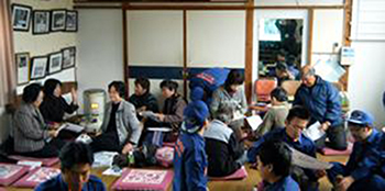
Community meeting
Discussion in the field
Copyright (C) 武雄河川事務所.All Rights Reserved.